Thursday, February 15, 2018

Winter at Grafton Lakes State Park

West side of Shaver Pond

Today's post is a bit closer to home than some of the previous ones, as in I live a mere 20 minutes away. But being close to the heart of the Capital District doesn't mean that Grafton Lakes State Park isn't a place worth visiting. There are plenty of easy to moderate hiking trails, most of which can be accessed without paying the summer parking fee, as well as a fire tower at the eastern edge of the park. I'm not here to do the fire tower, though (I did hike to it last spring). We had 6 inches of snow a few days prior, so I wanted to snowshoe.

I didn't want to do anything too crazy, so I settled on a hike around Shaver Pond. I parked at the Deerfield picnic area, strapped on the snowshoes, and was on my way.


That's the trail. From the parking lot.
Confirming that I indeed was on a trail. "More difficult" is relative.

After a short distance, we get to the Shaver Pond trail. This trail loops around the pond and, including the spur to/from the parking lot, makes for a hike of 2.1 miles.


Junction sign. Most junctions in this park are signed.

I turned left to make a clockwise loop and was on my way. The trail was generally pretty broken in, with plenty of ski and snowshoe tracks. The Shaver Pond Trail is blazed with RED NY State Parks and Historic Preservation markers and an occasional sign indicating the difficulty level.


The trail

The Shaver Pond trail doesn't have much in the way of elevation change, but the trail rolls gently. The trail hooks around the south end of the pond and I began hiking north along the west shore.


Shaver Pond from the southern end
Crossing the south inlet

This next section of the trail is right along the shore, soon reaching the signed junction with the Scout Trail.


Looking down the Scout Trail

Continue straight and we reach a bridge just downstream of a small dam. Shaver Pond, along with the other ponds and lakes in this area, was part of Troy's water supply system prior to the construction of the Tomhannock Reservoir.


Outlet bridge

A short distance after the bridge, there's an unsigned junction. Bear right here to continue along the pond.


Junction. Trail bears right here.

Junction number, located past the junction

[-]


Trail bears left here (note the marker)


Go another 1/4 mile and there's a T-junction. Turn right to continue following the Shaver Pond Trail.


Snow-covered picnic area


Old trail marker. DEC used a similar style in the past as well.

Eventually, we reach the end of the trail along the west side of the pond. A snowmobile trail runs east-west from Shaver Pond Rd to the area of the beach, turn right to start heading back to the parking lot.

The wide trail goes downhill and crosses the marsh at the north end of Shaver Pond


Marsh observation deck on north side of snowmobile trail

Immediately past an observation deck, the Shaver Pond Trail departs to the south.


The turnoff


The trail skirts the north side of the beach's wastewater facility and heads south along the east shore.


Near the middle of the pond, there were several groups ice fishing.


Ice fishing shelter
Bench and boat wash station


Go camping?

Eventually, all good things must come to an end and I was back where I started the loop.


Turn left here to get back to the parking lot

This didn't feel like a hill when I was hiking away from the car...

A little over an hour after I left my car, I was back. While Grafton may not offer the hiking opportunities of other nearby parks, it still has quite a few sights and you can't beat how close it is to civilization.


Getting There


Grafton Lakes State Park is located on NY Route 2, 14 miles east of Troy. The main road has an entrance fee during the summer, but entry is free at other times.

Thursday, February 8, 2018

Autumn on the Southern Tongue Range

View south from First Peak

As a kid growing up nearby, I always found the name of Tongue Mountain humorous. Maybe I still do at the age of 23. Anyway, I had never been up on this range and I thought it would be an excellent last hike in the Adirondacks before hunting season began in earnest. I'm working on the Lake George 12ster Challenge and 6 of the 7 peaks I needed (and 3 of the 4 I still need) are in the Tongue Range. I wanted to get one last big Adirondack hike in before hunting season started last October and, given that the leaves were nearing peak in this part of the state, I figured Tongue would be a good choice.

Basically, I decided to do a mega loop that got three of the 12sters in one shot while taking in some amazing views. In all, it ended up being a 13.15 mile loop that took roughly 8.5 hours, including breaks to catch my breath and enjoy the amazing views. The trail at the crest of the Tongue Range is NOT flat and the total ascent is roughly 3,000 feet, with several rock scrambles past Fifth Peak. The last 5 miles, on the other hand, are generally along the shore of Northwest Bay and, excluding a section from M=miles 11-13 that goes slightly inland, are pretty flat and I was able to move relatively fast. The ascent is generally concentrated in the first ~2 miles from the trailhead to the Tongue Range Trail. Even with the length of the hike, it is the easiest way to get the three southern Tongue peaks that does not involve a boat or another driver.


GPS track of the hike loop. Numbers are miles.


Elevation/Time graph (time in motion). The trek across the range has quite a bit of elevation change, with some of the cols being over 350 feet deep.
Map of the area
(National Geographic Map 743 (Adirondack Park: Lake George / Great Sacandaga))

I would strongly recommend doing the loop clockwise (that is, head south along the top of the range and return along the lakeshore), as the second half of the hike will then be almost entirely flat or downhill. A few other notes:

  • There is no water along the trail other than Lake George itself (which MUST be filtered if used for drinking) except after storms and in the spring. Unless you're willing to bring a filtration system in, pack your water with you.
  • I did not see any, but there are supposedly rattlesnakes on the range. Watch your step and where you put your hands on the scrambles.
  • You can do this as a multi-day hike. The summit of Fifth Peak has a lean-to and there are several places one could put up a tent, especially along the lake. I did not see any toilet facilities along the trail.
  • This area doesn't get a lot of people owing to the difficulty of the hike, as there are much easier hikes with good views nearby. Except for a couple leaving the summit of Fifth Peak as I arrived, I saw no other hikers. If you get in trouble, don't count on someone finding you for a while. The trail along the range crest generally has cell reception, but lower elevations (including along the lake) do not.

I arrived at the Clay Meadow parking area on NY Route 9N around 8:30 on a crisp Thursday morning. Made the decision to leave the jacket in the car and started on my way. Trail register is a short distance down the trail on the left. We start on the Northwest Bay Trail (ADK Eastern Trails #55, blue markers). The first 0.4 mile is mostly downhill, with a long bridge over the northern tip of Northwest Bay. A little past the bridge, we reach a junction. To the right is the Northwest Bay Trail to Montcalm Point. Straight ahead is the Five Mile Point trail across the range (ADK Eastern Trails #56, red markers). Straight is what you want. The next 1.6 miles is a pretty steady climb that can get steep. A few switchbacks help with the climb and there are some large rocks if you need a break (I certainly did). At the top of this climb, 2 miles into the hike, we hit the junction with the Range Trail at the Saddle. Elevation here is about 1,500 feet, about 1,180 feet above the lake.


Saddle Junction with Tongue Mountain Range Trail
From here, you could go straight and descend 1,180 feet to Five Mile Point, but since that is a dead-end with little in the way of views, it is not recommended unless you have a boat to pick you up. I turned right onto the Range Trail (ADK Eastern Trails #53, blue markers). There's a moderate climb over the next ~0.4 miles, where the spur trail to Fifth Peak (yellow markers) branches off to the left. Take the spur trail and, 1/4 mile and a final steep climb later, you reach the summit. Fifth Peak, elevation 1,813 feet, is the highest point on this hike and one of the 12sters. I searched the summit, but did not find a benchmark.


Looking southeast from Fifth Peak

Looking northeast from Fifth Peak

Take a rest in the lean-to and enjoy the view. You could turn around here for a 5.5-mile round trip. I'm here to tell you that the best views are still to come. When you're ready to push on, retrace your steps and turn left (south) onto the Range Trail. From here to French Point Mountain, it's about 2 miles and anything but easy. There's a small ascent to a southern sub-peak of Fifth (elevation ~1,725 feet), followed by a sharp 300 foot descent to Fourth Peak (unmarked) that involves the first significant scrambling. The up and down continues across Third Peak (unmarked) and up to French Point Mountain. French Point (elevation 1,739) is the day's second 12ster and about 5 miles into the hike.


The summit and sign
I could not find a benchmark in the area, but the summit is signed. French Point Mountain has some good places to sit and an excellent panorama of the Lake George Narrows 


Looking south at the Lake George Narrows

I took advantage of the seating and view to eat my lunch. When you're ready to head over to First Peak, head back to the trail and continue south. First part of this is bare rock; follow the paint blazes. Very sharp descent off of French Point with some steep scrambles. We hit the col between French Point and First around 1,250 feet and begin the climb up.


View between French Point and First Peak

At the top of this climb is First Peak. First Peak, elevation 1,586, is the shortest of the 12sters, but that doesn't mean the view is small.


No benchmark, just this sign

The view south


Another look south

First Peak may have the best views on this hike and the best on the entire 12ster Challenge. I can't help but think this was the view referred to by Thomas Jefferson in a 1791 letter to his daughter:

Lake George is without comparison, the most beautiful water I ever saw; formed by a contour of mountains into a basin... finely interspersed with islands, its water limpid as crystal, and the mountain sides covered with rich groves... down to the water-edge: here and there precipices of rock to checker the scene and save it from monotony. (Thomas Jefferson, 1791) 

What goes up must come down. When you're ready, it's a little under 2 miles and 1,250 feet down to the junction with the Northwest Bay Trail. Get ready for more views and scrambles.


Lots of views on the way down, though


Eventually, you get to the junction.

Junction sign

No matter which way you look here, the markers are blue. You could continue straight for 0.4 miles to Montcalm Point. Supposedly a beautiful view. However, I was afraid I'd run out of daylight, so I took a sharp right and began the 5-mile trek back to Clay Meadow.

This trail is generally pretty flat, with a few bridges.

Bridge over seasonal stream
There's a few hills as you get near the parking lot. About 0.4 miles from the parking lot, we hit the junction with the Five Mile Point trail (remember this from earlier?). Turn LEFT to go back to your car and civilization.

I'm not going to say that a hike along the Tongue Range is easy, but it is by far the most scenic hike I have taken in this part of the Adirondacks. Show up early so you have enough daylight (unless you want to camp, of course) and I can assure you that the fall colors are amazing.


Getting Here

Trailhead is located on NY Route 9N about 4.5 miles north of Warren County Route 11 (the main access to Northway Exit 24) and 6 miles north of Bolton Landing. It's roughly 10 minutes from Northway Exit 24 to the trailhead. If coming from the south, both trailhead and parking are on the right, with parking being roughly 250 feet north of the trail. The lot can hold ~10 cars.


Resources


  • The Adirondack Mountain Club's (ADK) Eastern Trails book. The best trail guide for this section of the Adirondacks and my main resource here.
  • National Geographic's Adirondack Park: Lake George / Great Sacandaga map (#743). It's waterproof and the trail numbers match ADK's guide. Can be bought as a set with the guide if you want to save a few dollars.

Saturday, February 3, 2018

South Beacon Mountain and Scofield Ridge

Beacon, Newburgh, and the bridge from the fire tower.
(All pictures mine)

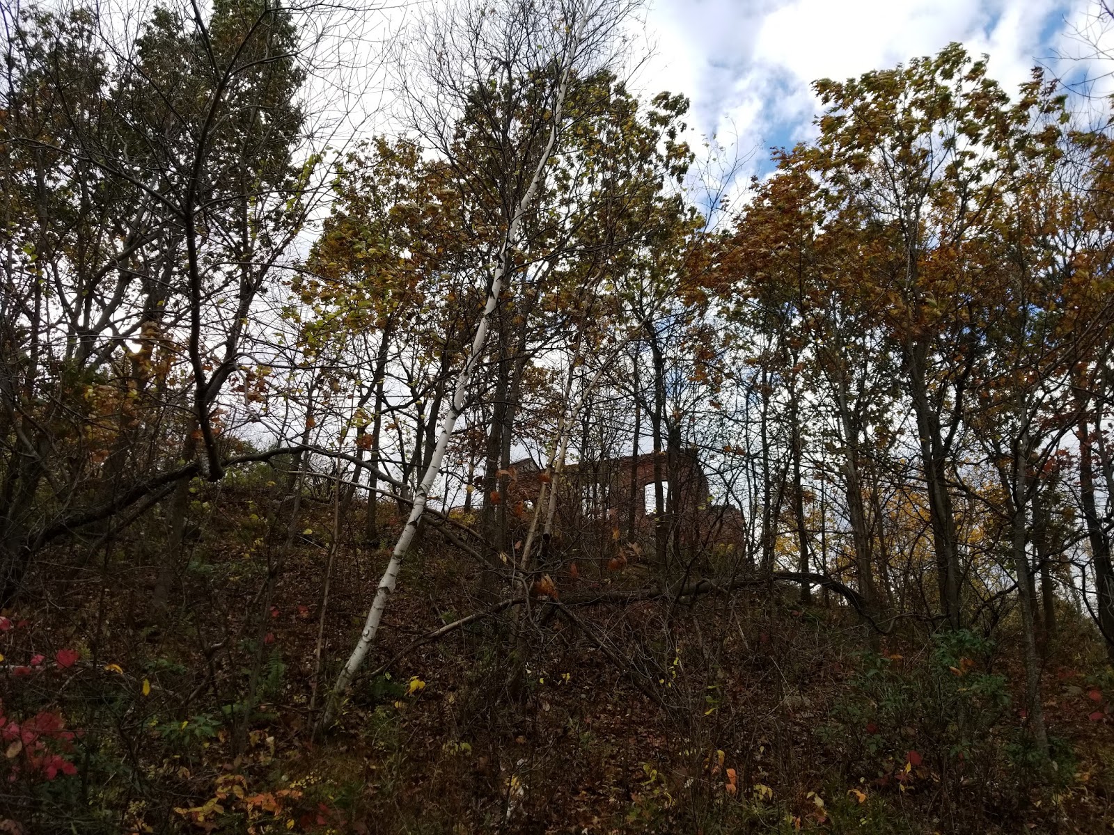
South Beacon Mountain may be one of the most underrated hikes in New York. The trailhead is within the city limits of Beacon, but there are tons of ruins (including an abandoned incline railway), a fire tower, and the high point of Putnam County. If you look carefully, you can see the fire tower and ruins from the Newburgh-Beacon Bridge and the route of the incline railway is impossible to miss. Really easy to get all of these in a hike of around 6 miles (with most of the ascent being in the first mile out of the trailhead). That being said, it's a climb. From the trailhead to the summit of South Beacon Mountain and the fire tower is a vertical ascent of over 1,400 feet. Need to lose and regain a little bit to get over to the summit of Putnam County on Scofield Ridge. But definitely a climb I'd recommend making, as the views are stunning and there's quite a bit of history on this mountain.


The parking area at the corner of Wolcott Avenue (NY Route 9D) and Howland Avenue can hold a few dozen cars and contains portable toilets and a kiosk with trail maps. If the lot is full (likely on weekends when the weather is nice), ample parking is available on the side streets. But parking wasn't an issue when I showed up around 10:00 on a Thursday morning (yes, I did plan my class schedule so I'd have a day open to hike every week). The first 0.2 miles or so is a wide gravel path with a slight upgrade. Trail markers are RED. Soon, the ruins of the old Mount Beacon Incline Railway come into view.

Former incline railway station


Looking up the incline railway


When constructed, the Mount Beacon Incline Railway was the steepest incline railway in the world. It was abandoned in 1978 and added to the National Register of Historic Places in 1982. Groups are fundraising to rebuild the railway.

Oh, right, the trail

The trail begins to parallel what was the world's steepest incline railway with a long metal staircase. 100+ feet further above the Hudson River Estuary, the staircase ends and there's a sharp left turn away from the railway around an elevation of 400 feet.


The views start near the top of the stairs


A short distance and 100 vertical feet later, you're faced with a decision. Continue straight onto the yellow trail, or take a hairpin turn to the right and continue climbing on the red trail. You want the red trail, as yellow takes you around the mountain.


Yeah, it's steep. Keep climbing. It's worth it.


Getting closer...

If you keep climbing along the red trail, you'll reach the ruins of the Mount Beacon Casino and Incline Railway at around 1,200 feet, approximately 1 mile from the parking lot. There's roughly 1000 feet of vertical ascent from the parking lot to this point.

First, we reach the former powerhouse for the incline railway.


The powerhouse


Hoist mechanism 
Looking down at where people boarded/alighted


Continue a short distance further to reach the ruins of the Mount Beacon Casino.The Casino was once a major tourist attraction, with panoramic views of the Hudson Valley and Hudson Highlands. While the building is gone save its foundation, the view remains.


View of Beacon, Newburgh, and the bridge connecting them.
The Shawangunk Ridge is in the background.


Looking southwest


Looking south toward Storm King Mountain


Old steps


The casino once stood here


South corner of the foundation. Fire tower is at the top left.


View south toward the Hudson Highlands
If you want, you could turn back here, which is what most people do. I'm going to tell you to continue along the red trail, as the hardest part of the hike is over and the rest is a cakewalk. The first part of this trail is along an old road, but the trail diverges as the road heads north to the Beacon Reservoir. There's a slight descent into the col between North and South Beacon Mountains, but the climb soon resumes. Just under 2 miles from the parking lot is the junction with the white trail. You want to turn onto the white trail to get to the fire tower. It's really hard to miss the junction.


That's the junction, white trail diverges to the right.
I counted no fewer than 7 white trail markers here.

The white trail climbs moderately, but it's a short climb.


Compass painted near the summit


The fire tower
Soon you're standing on the summit of South Beacon Mountain, not even 1/4 mile from the red trail. The summit and fire tower are a short distance off of the main trail, but very east to find. South Beacon (elevation 1,610 feet) is the highest peak in the Hudson Highlands and far above the Hudson River less than 2 miles to your west. 


Looking toward Beacon


Looking toward Storm King


As if the view from the ground isn't good enough, the fire tower gets you higher.


Beacon, Newburgh, and the bridge from the fire tower

Looking south


Looking east


Looking north at the Beacon Reservoir

I would not be surprised if you could see the Manhattan skyline from up here on a clear day. Sadly, the day of my hike was not clear.

Once I was done bracing myself against the day's high winds, I made my way down the tower and retraced my steps to the red trail. Unless you want to do a long loop or are a county highpointer, you'll probably turn left to return to the trailhead. Not much interesting stuff beyond this other than the high point of Putnam County. turning right at the junction to continue on. The red trail ends shortly later, and I turned right on the yellow trail to continue to the Putnam high point. Some minor scrambling awaited me on the yellow trail as I neared my destination about half a mile from the end of the red trail. The high point of Scofield Ridge (elevation 1,540 feet) is pretty darn easy to find because there's a giant yellow X on the exposed rock.


X marks the spot

To make your life easier if you're a highpointer, it is where the trail has a 90 degree turn, the trail going NE and SE from the point, approximately 1,500 feet due east of the South Beacon fire tower. 


Looking west toward the fire tower


View east from Scofield Ridge

Scofield Ridge isn't a "liner" (high point on a county line", but it's darn close, being less than 200 feet inside Putnam County.

From here, I could have continued around to make a loop, but I had other plans for the day, so I retraced my steps back to the red trail and down to my car. Aren't a ton of amazing hikes within the limits of a city in New York, but trust me, this one is worth it, even if there are crowds.


Getting Here


This is one of the easier trails in the region to get to. NY Route 9D is a relatively major road and it's not too far from Interstate 84 and the Newburgh-Beacon Bridge. Plenty of services nearby if you need a last-minute snack or the like. The popular Breakneck Ridge trailhead is a few miles south along 9D, but that trailhead will be closed until mid-2019 for improvements.


Resources


  • Hudson Highlands State Park. The majority of the trail lies within this park.
  • Avenza Maps Navigation App. The NY Department of Parks, Recreation, and Historic Preservation makes all of their maps available for free using this app. The maps have GPS tracking and I make use of them when hiking in a state park.
  • Hike the Hudson Valley's Mount Beacon Page. This is the main hiking resource I used to find out what I was getting into.