 |
| View of the Manhattan skyline from Jackie Jones Mountain fire tower |
Harriman State Park in Orange and Rockland Counties, NY is part of the third-largest protected area in New York, behind only Adirondack and Catskill Parks in size when combined with adjacent state parks and federal land. With rugged terrain, hiking ranging from easy to strenuous, breathtaking vistas, and many amenities, it's no wonder this place is often called "New York City's playground". Jackie Jones Mountain, with a summit 1,280 feet above the Hudson River and sea level, has a completely unobstructed view of Midtown Manhattan (32 miles away) if you're willing to climb the fire tower. While Rockhouse Mountain may supposedly be 3 feet higher (and thus Rockland County's high point), neither Rockhouse nor Jackie Jones Mountains have been formally surveyed and the fire tower cab is a good 50 feet above Rockhouse, so Jackie Jones is officially a high point candidate. If you're going for the NY county high points, you need to head over to Rockhouse and bushwhack that in addition to hiking this, but I would not recommend hiking that mountain unless you're dedicated to high points. Jackie Jones is a much better hike that you're bound to enjoy.
The hike up Jackie Jones Mountain is approximately 2.5 miles (round-trip) with roughly 400 feet of vertical ascent. It's a moderately-easy hike that is child-friendly. I made the hike in an hour (not including a break at the fire tower to enjoy the view), but I'm also used to far more taxing terrain.
Parking my car at the parking area along County Route 106 west of Haverstraw, I walked the short distance west along the road to the trailhead on the far side of a creek.
 |
| Looking back toward parking area (right side of road) from trailhead |
The trailhead here is not clearly signed as such, instead looking like an access gate. It is, in fact, an access gate for the communications tower near the summit
 |
| Access gate/trailhead |
 |
| Old lettering at the base of the access gate |
The Suffern-Bear Mountain Trail, blazed in YELLOW, initially follows the paved access road.
A short distance into the woods, the trail bears to the left off of the access road. Follow the blazes here! While the access road could take you to the summit, it bypasses the interesting parts of the trail.
 |
| Typical blaze |
The ruins continue along the trail for some distance.
 |
| Old gatehouse |
Past the old gatehouse, the marked trail takes a turn to the right. However, continue straight to view some more ruins.
Returning to the trail, it continues up the mountain, but more ruins can be found alongside the trail.
Eventually, it's time to leave the ruins behind as the trail makes a sharp turn to the right and becomes unpaved.
A little under halfway in, the trail makes a sharp turn to the right.
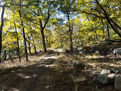
The landscape in and around Harriman State Park is quite rugged, with many exposed rock surfaces and boulders littering the ground that must be climbed over.
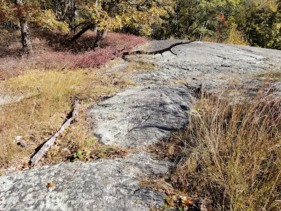
About 1 mile in, the foliage thins as the trail climbs and then crosses an exposed slab of rock. This is the most difficult portion of the trail.
 |
| They really don't want you to miss this turn |
At a sharp left-hand turn, the communications tower near the summit becomes visible.
Near the communications tower, the trail rejoins the service road for the final stretch.
About 1.25 miles from the trailhead, we reach the summit of Jackie Jones Mountain and its 60-foot fire tower. The fire tower was restored in 2018 and provides an excellent view of the region.
Since Jackie Jones Mountain is a forested summit, the only way to get a view is to climb the tower.
But once you start climbing, the views are worth it.
 |
| Yes, that is Manhattan in the distance |
 |
| Looking northeast |
 |
| Lake Welch |
 |
| A zoomed-in view of the Manhattan skyline. The Empire State Building and 1 WTC are clearly seen. |
 |
| Looking north |
 |
| One last shot while descending the tower |
Something I did not notice on the way up was that the exposed rock section had a yellow-painted spike serving as a blaze.
 |
| Looking downhill across the exposed rock |
I knew the trailhead was near when I reached the ruins.
 |
| Nest hidden in a bush |
 |
| Tree that had fallen across the path |
Back at the access gate, my hike was complete.
 |
| Old stone structure next to the gate |
Jackie Jones Mountain is a great easy-moderate hike that is easy to combine with one of several other hikes in the Harriman-Bear Mountain area. It probably gets quite busy on summer weekends, but on a Thursday in October, I had this section of the park to myself.
Getting Here
The trailhead for Jackie Jones Mountain is located along Rockland County Route 106 (Kanawauke Road) between Lake Welch Parkway and the Palisades Parkway. An entrance fee is NOT charged to access this hike, but be aware that it is popular and the small parking area may fill on weekends or during the summer. Parking is located just to the east of Minisceongo Creek, trailhead is just to the west of it. Both parking and trailhead are on the south side of the road.
If visiting the park in the offseason, note that Lake Welch Parkway and Kanawauke Road west of Seven Lakes Drive are not maintained in the winter months.
External Links
Harriman State Park: official websiteHike description from New York - New Jersey Trail Conference: information about this hike and a longer hike that can be taken using this hike


