 |
The now-abandoned town common in Dana
(All pictures mine unless otherwise noted) |
The Quabbin Reservoir, located in a rural area of eastern Franklin and Hampshire Counties and western Worcester County, supplies much of the water used in Greater Boston. When the decision was made to flood the Swift River valley and create the reservoir, the State condemned and purchased most land in the watershed above the planned dam site in order to protect the quality of the water. Much of the watershed land, with the notable exception of the large peninsula south of New Salem, is open to the public. This makes for some unique hiking opportunities.
Four towns were dissolved on April 28, 1938 due to reservoir construction. Enfield and Greenwich were mostly low-lying and are thus mostly submerged.
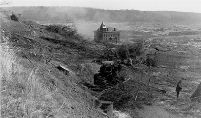 |
The destruction of Enfield Center. Town hall in center.
The town center is now underwater.
Source: https://en.wikipedia.org/wiki/File:FarewellEnfieldTownHall.png |
Prescott is mostly above water, but largely inaccessible, as most of the above-water land is on the restricted peninsula south of New Salem. And then you have Dana. Unlike the others, the former town center, Dana Common, remains accessible to the public. That is, if you're willing to park at Gate 40 and walk 1.8 miles along a long-abandoned road now used only by foot traffic, bicycles, and service vehicles.
 |
Map of the area. Parking is at Gate 40.
Dana Common is at the intersection under the "North" arrow. (Massachusetts DCR)
Source: https://www.mass.gov/service-details/public-access-maps |
January 27 was an unseasonably-warm day, so I decided to do my planned hike to Dana. Gate 40, along Massachusetts Route 32A in Petersham, has parking for 6-7 cars, but it is NOT marked. Strongly recommend using a navigation app or GPS to get here. If you insist on going in without assistance, Gate 40 is a driveway leading to the small parking lot.
 |
| The parking lot. MA Route 32A is in the background. |
Don't block the gate, as it is the emergency vehicle access point for the trail and you will get towed.
 |
| The gate, kiosk in background. Sign says what is prohibited. |
 |
| Leave Fido at home. Dogs are not allowed on watershed land. |
A short distance past the gate is a kiosk, providing a wealth of historical information and a map of the area.
 |
| History, map, and regulations kiosk at trailhead |
The Town of Dana was settled in 1763 and incorporated in 1801. Due to water power and rail access, it became a manufacturing center, eventually becoming the first town in the Swift River Valley to have electricity and the only town in the valley to have a motorized fire truck. The town common was listed on the National Register of Historic Places in 2013.
 |
| Asphalt is in acceptable condition and the road is relatively clear |
 |
| Uh, oh, looks like ice ahead |
The "trail" is the old road to Dana, still with its asphalt that likely predates the 1930s. It appears to be plowed in the winter and, while I had poles, I only used them for assistance on ice.
 |
| Yup, a thick sheet of ice across the entire road for about 200 feet |
It generally looks and feels like a rural road in this part of the country, minus the vehicle traffic. There's a small hut of some sort past the icy patch.
The trail was pretty lonely, and I only passed one walker and one bicyclist before I started returning to the car. About a mile in, we start seeing real signs of former residents. Cleared fields appear, along with our first house foundation on the right.
 |
| A former orchard? |
 |
| Foundation of an old farmhouse? |
 |
| Cleared field |
 |
| Old wall |
 |
| Another old wall |
On the right (north) side of the road, there appears to be an old alignment of this road. It too appears to have been paved at one point, at least partially.
 |
| The old, old road |
Just past the old road, evidence of habitation increases significantly, with more foundations. Around a bend is the former town center.
Overall, I spent about 1:45 walking to/from and exploring the ruins, but I'm accustomed to walking on rough terrain. Even though the walk was flat, it was definitely a unique experience and a place you should visit.
Red Tape
Being as this is a public water supply, there is some red tape associated with this hike.
- Parking is extremely limited. Not many places to park on the road nearby, either. If you show up at a busy time, good luck finding parking. You may be able to park at Gate 43 on Greenwich Rd, but it is a much longer walk and a bicycle may be useful.
- Dogs are explicitly prohibited, as mentioned above. This is almost certainly to protect water quality. I did see one person with a dog when I was there, but I expect that the area is patrolled during nicer weather.
- There are supposedly portable toilet facilities during the main season, but there definitely were NOT when I was here. Nearest reliable public restrooms are in Ware, Barre, and Athol.
Getting Here
While not particularly far from either Worcester or Springfield, this is a relatively remote area that gets little traffic. Cell service is limited and I did not have reception at any point during the hike. Do NOT rely on being able to find the location online if you are near the trailhead.


