 |
There's a reason they're called ice caves
(All images mine) |
The Shawangunk Ridge, the northernmost portion of the 250-mile ridge known as the Kittatinny Mountains in New Jersey and Blue Mountain in Pennsylvania, is the easternmost barrier ridge in the Ridge and Valley Province stretching from Alabama through New York. The Sam's Point Preserve, now part of Minnewaska State Park, occupies the highest portion of the Shawangunk Ridge, with the loop carriage road reaching an elevation of 2,289 feet, the second-highest peak on the ridge if the extension through Pennsylvania is included and nearly 500 feet higher than New Jersey's High Point on the same ridge. This area contains many interesting geologic features, notably the Ellenville Fault Ice Caves. These caves, which contain ice through much of the year, are located in deep fissures on the southeast face of the ridge.
Much of the Sam's Point area contains a unique and fragile ecosystem, consisting of dwarf pine barrens. The area was hit by a forest fire in Spring 2016 and, while the pine barrens require occasional fires to maintain the ecosystem, the fire did not burn through all accumulated debris and there is concern that the pitch pine will not properly recover. Evidence of the fire is still visible on the ridge and, to prevent future unplanned fires, all forms of campfires and cooking are prohibited within the Sam's Point area. Due to the uniqueness of the landscape, I was taking pictures almost constantly, with nearly 500 in total. For this reason, this post is long and there are pictures showing virtually everything you will see on a hike in the area.
There are three main options for hikes out of the Sam's Point trailhead that can be done using the guide I'm doing here. All of these visit the ice caves and two visit Verkeerder Kill Falls (on private land just outside of Minnewaska State Park). High Point could be visited without Verkeerder Kill Falls or the Ice Caves, but most of the direct trail is a former carriage road with no views.
- Out and back to the ice caves. The ice caves are the main attraction of this section of the park and views across the Hudson Valley can be had from the Sam's Point overlook near the halfway point. Other than the 0.5-mile ice caves footpath loop, all of this trail is a paved or gravel former carriage road. The portion along the top of the ridge is through a dense stand of dwarf pitch pine, uncommon in New York and existing here solely because of the cool microclimate created by the caves (About 4 miles if you do everything, difficulty 3/5).
- Out and back to Verkeerder Kill Falls with a detour to the ice caves. The portion of this trail past the Ice Caves junction is a narrow footpath, mostly through an alpine-like environment of bushes and scattered dwarf pitch pine (a little under 9 miles, difficulty 4/5).
- Loop that visits the Ice Caves, Verkeerder Kill Falls, and High Point with a seemingly-endless set of scrambles between the falls and High Point. Do note that High Point is NOT the highest point on the ridge, with surveys indicating that the carriage road gets roughly 40 feet higher near the radio towers (10.6 miles, difficulty 5/5).
This is NOT nearly an exhaustive list of potential hikes from the trailhead. There are several combinations of hikes, whether they be round trips or through hikes. Check the
park website before going to ensure your planned destination is open.
The ice caves are closed in the winter and early spring, often not opening until around Memorial Day. Why, you may ask? There is too much ice in the winter and early spring for the trail to be safe.
A key aspect that sets this hike apart from many I do is the parking fee. A $10 per vehicle fee is charged to park at Sam's Point, payable by credit card or exact cash at a pay station or by cash or check at the visitor center. The fee is typical of staffed state parks in New York and, in addition to funding the staff and visitor facilities at the park, helps to prevent overuse of the area. That being said, I strongly recommend carpooling if hiking with a group due to extremely limited parking. The lot does fill on weekends. The place is relatively empty midweek and I had the caves area to myself.
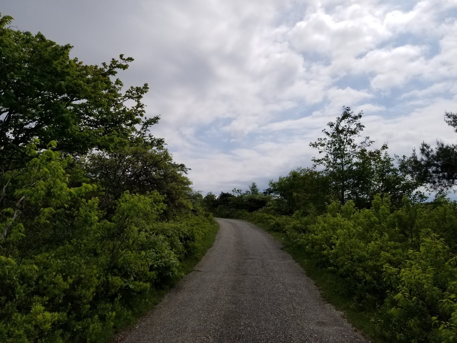
After paying my entry fee and obtaining a map from the visitor center, I started up the trail around 10 AM on a cloudy Tuesday morning. It rained a bit when I was driving down (and I would get more later), but for the time being, it was pleasant. Leaving the parking lot, the trail is a well-maintained gravel carriage road.
 |
| Signs near trailhead |
Immediately, the trail splits. Right leads to Sam's Point itself, the ice caves, and Verkeerderkill Falls, left (well, straight) is a direct trail to High Point and the rest of Minnewaska State Park. You could get to the caves and falls by going that way and looping around Lake Maratanza, but it adds a mile.
Going to the right, there's a boot brush and sign encouraging people to clean their boots before hiking further. The 2016 fire made the region vulnerable to endangered species.
 |
| Sign at boot brush |
The trail begins to ascend gently. A stone market commemorates the former landowners.
 |
| Shortly before first switchback |
Less than 0.2 mile from the parking lot is the first of two switchbacks.
 |
| Looking uphill from first switchback |
A second switchback follows roughly 0.2 mile later, then the trail starts to get interesting. A pile of boulders is located on the right side of the trail.
 |
| Rocks along trail |
 |
| Looking uphill |
Looking through the trees to the left, some of the Shawangunk Ridge's famous cliffs can be seen.
 |
| Shawangunk Ridge cliffs |
Continuing the gentle climb, the cliffs get closer to the trail...
 |
| What's that up ahead? |
until the trail is next to them.
The cliffs here show significant evidence of faulting, with many large crevices.
Around this point, the carriage road becomes paved. Roughly 0.6 mile from the trailhead, an open rock ledge is to the right of the trail. Stepping out onto the ledge gets the first panoramic view of the hike.
 |
| Looking southeast from ledge |
 |
| Looking south |
 |
| Looking southwest |
 |
| The ledge is made up of conglomerate |
Looking back toward the trail, I set off toward the official Sam's Point overlook a short distance away.
 |
| Looking downhill along carriage road |
Roughly 200 feet uphill from the ledge is the turnoff for the Sam's Point overlook, located on the left.
Following the arrow, walk about 400 feet until you're at the edge of the cliffs
The view up here is even better than what you get at the ledge.
 |
| Looking south from Sam's Point |
 |
| Looking southeast |
A USGS reference that has taken many lightning strikes is located on the bare rock. I did not see the benchmark.
 |
| Reference Marker #2 for Sam's Point |
 |
| Looking southwest along ridge |
A small bridge across a deep crevice allows hikers to access another part of the ledge.
I'm going to spare everyone the talk and just show some of the pictures I took up here.
 |
| Looking down at the carriage road |
Sam's Point isn't even one of the biggest attractions on this trail, so I left it behind and continued on.
 |
| The small bridge |
Returning to the main trail, I turned left and continued hiking along the crest of the ridge.
This section of the hike is very easy and is generally paved.
As we near the ice caves, the foliage changes to dwarf pitch pine.
 |
| A stand of dwarf pitch pine along the trail |
A little over a mile from the trailhead, there is a wide junction and another carriage road departs to the right. This is the trail leading to the ice caves and Verkeerderkill Falls.
 |
| Approaching junction |
 |
| Junction signs |
The Ice Caves carriage road descends slightly, providing a view of the valley to the southeast.

0.1 mile after the Ice Caves Road breaks off of the Loop Road, the Verkeerderkill Falls footpath and Long Trail depart to the left.
 |
| Looking down the Verkeerder Kill Falls footpath. We'll be back here after the caves. |
The Ice Caves Road continues onward and downward, curving to the left (northeast) and providing excellent vistas.
 |
| View northeast along the ridge |
Roughly 0.3 mile from the loop road and 0.2 mile from where the falls trail turns off, we reach the west end of the Ice Caves loop trail on the right. I'd strongly recommend starting here, instead of continuing a short distance down the road and starting from the other end, as this saves the best sights for last.
I would strongly recommend bringing a light source, whether it be a phone or flashlight. Most of the darkest areas are lit, but there was one place where the light on my phone was useful. Once you're ready to go, start down the trail.
 |
| Beginning of loop is behind that boulder |
Initially, we descend along a rocky trail through a stand of trees.
 |
| Beginning of loop |
At the entrance to the caves themselves, another warning sign guards the point of no return.
If you're ready to proceed, down into the abyss we go. Most of this trail consists of stairs, with a couple of ladders. Little true scrambling is required.
As we continue to descend, we pass under a ledge and enter a narrow crevice. At this point, I started to feel a cool breeze.
 |
| Yes, that's the trail |
Before we go any further, let's appreciate the unique geology of the ridge.
 |
| Looking back at where we just were |
Reaching the bottom of this crevice, the trail makes a sharp right turn, followed by a U-turn to the left.
 |
| Approaching the bottom of the crevice |
 |
| What I just came down |
Soon enough, the crevice opens up at the bottom of a cliff and the trail turns left (northeast) to follow the cliff.
We soon duck into another crevice.
This portion of the trail hugs the cliffs closely, winding in and out of crevices.
Down here is the first portion of the hike that requires artificial light. Thankfully, there's a solar-powered light in the cave.
The darkness is short-lived and we soon pop back into the light, climbing up stairs in another narrow crevice.
 |
| Follow the arrows! |
 |
| Please don't write on the rock |
In a couple of places down here, the trail winds through boulder fields.
 |
| This is the closest thing to a scramble near the caves |

At two locations, wooden ladders are provided to help with ascending.
 |
| Crevice next to the trail |
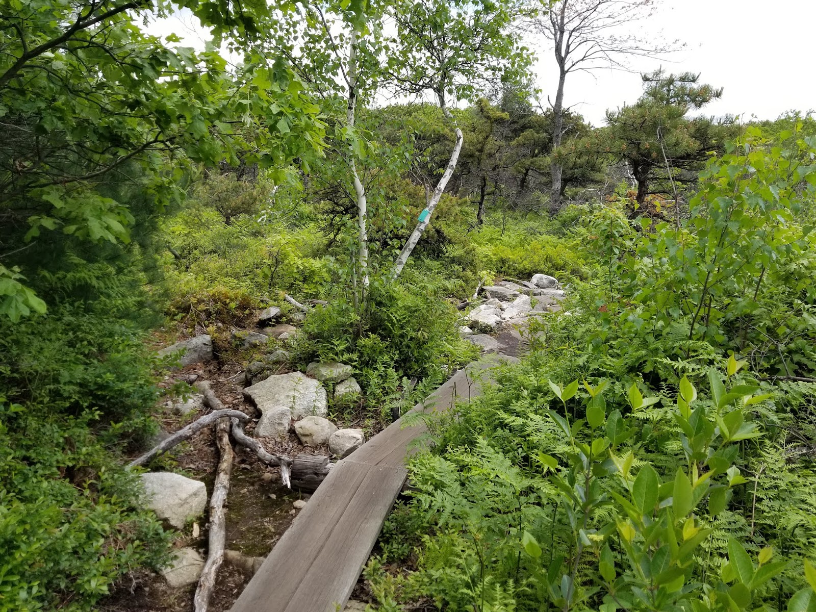
After the ladder, a boardwalk section is provided to cross a muddy area.
 |
| Looking back |
 |
| Looking ahead |
The second dark area did NOT have any working artificial light. At least at the time, a flashlight was necessary to safely pass through.
 |
| Taken with the assistance of flash |
 |
| Looking out the far end of this cavern |
 |
| There were lights, but they didn't work |
 |
| Looking back into the cavern |
A very short distance from cavern 2 is the third and final cavern, which DID have working lights. This is the longest cave the trail passes through and much of the path through here is on a wooden boardwalk.
 |
| Boardwalk entering the final cavern |
The last cavern is also where you're most likely to see ice. If you look at the ground in the picture above, there is indeed a layer of ice in the cave, 2 months after the last freeze. It is not uncommon for ice to last here until late in the summer due to the protection provided by the cavern.
 |
| Yup, that's ice, alright |
 |
| Looking back toward entrance of third cavern |
The boardwalk makes a sharp turn to the left, passing out of natural light.
The exit of the last cave is the cover picture for this post, a thick sheet of ice that had to be carved down to allow a path to pass through. The ice here is at least 1 foot thick.
 |
| Looking back in cavern |
 |
| Trail passing through thick ice sheet |
 |
| Ice next to exit stairs |
A rock staircase serves as the exit from this cavern.
 |
| Looking back into cavern |
 |
| From top of stairs |
The second ladder on this trail is found at the top of the stairs, allowing us to climb to the top of the cliffs.
 |
| Second ladder |
A bridge takes the trail across a crevice. An overlook is found at the far side of the bridge.
 |
| View from overlook |
As mentioned previously, the lights in the caves run on solar panel. A solar panel is located at this overlook.
The trail returning to Ice Caves Road is similar to the trail leading down to the caves.
The trail suddenly becomes gravel and widens significantly, marking the end of the loop and the east end of Ice Caves Road.
If your sole intent was to visit the Ice Caves, you can retrace your steps back to the parking lot from this point. If you want to continue on to the falls and/or High Point, keep reading.
From here, I backtracked roughly 1/4 mile to the Verkeerderkill Falls trail.
 |
| The junction from the Ice Caves side |
Back at the junction, I turned right on the aqua-blazed Verkeerderkill Falls footpath and Long Path. Much of the 2 miles or so between here and the falls is through a dwarf pine barrens and is quite open with little shade.
 |
| Beginning of Verkeerderkill Falls footpath |
While the trail is generally easy to follow in this section, pay attention to blazes painted on trees and rocks.
 |
| Looking to the right (southeast) from trail |
Many Long Trail thru-hikers list this as their favorite section of the trail and for good reason: there are excellent views to the southeast and it is unlike anywhere else in New York.
Most of the trail to the falls looks like this.
 |
| Descending through a stand of dwarf pines |
 |
| In a few places, you need to climb over large boulders on the trail |
Breaking up the pine barrens are scattered larger trees and a couple of boardwalks.
 |
| Small stream crossed by one of the boardwalks |
This section of trail has the first easily visible evidence of the 2016 fire.
 |
| Note the charred branches |
 |
| Pay attention: many of the blazes are along the ground |
 |
| Occasionally, there is a Long Path marker along the trail |
As we get close to Verkeerderkill Falls, the trail leaves the state park and enters private land. Please stay on the trail and leave no trace.
A short distance onto private land, the trail ducks into the forest.
A handful of stream crossings lie between here and the falls.
 |
| I'd recommend water-resistant footwear |
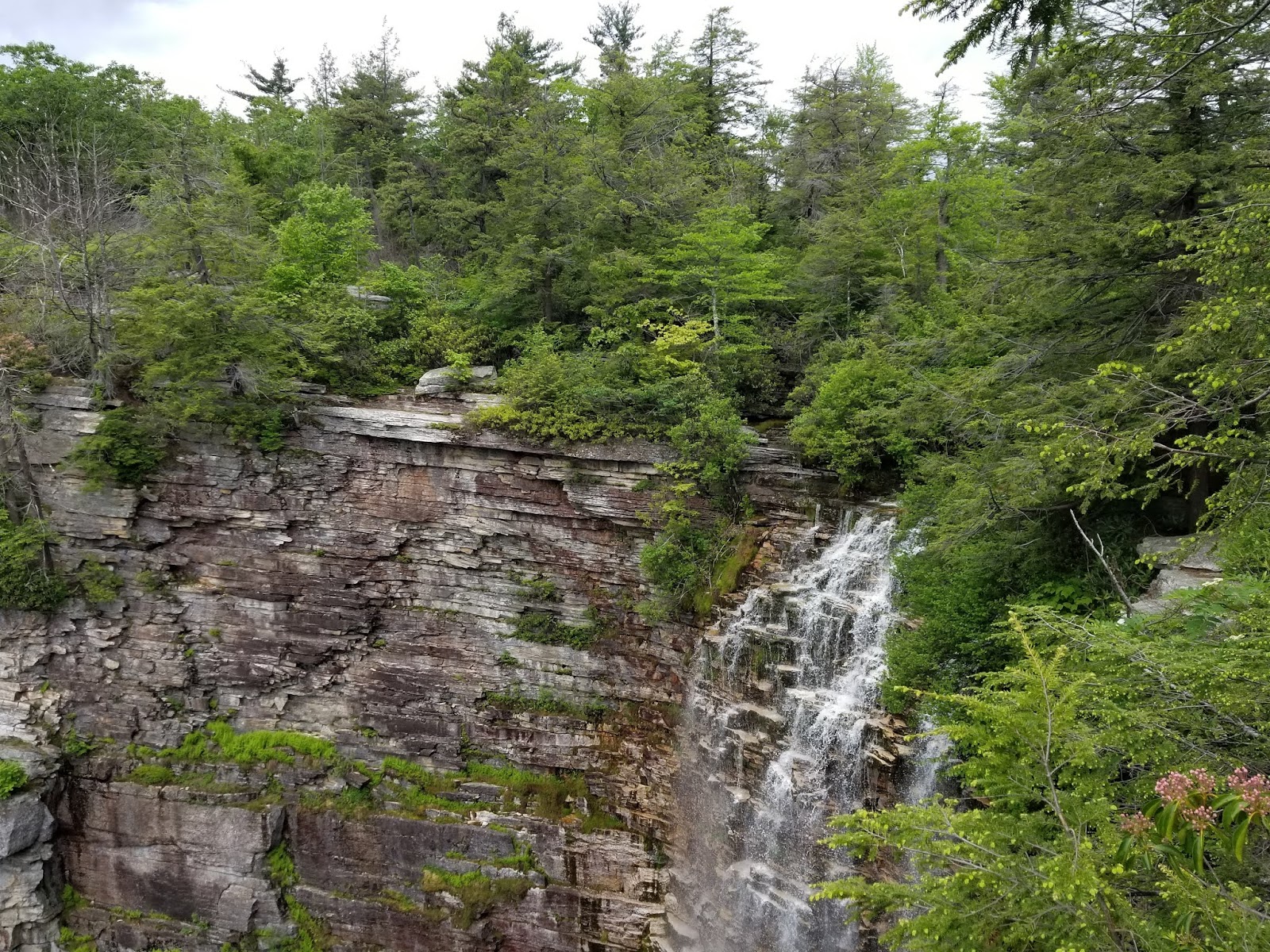
The final ford is across Verkeerder Kill. A short distance to the right of the ford is the crest of the falls. DO NOT APPROACH THE CREST. There are no railings anywhere near the falls. While this allows for unobstructed views, it also means there is nothing between you and a 200-foot drop.
 |
| Crest of the falls |
 |
| The trail is a few yards from the crest |
Immediately after this ford, the trail turns to the left.
To the right is an overlook adjacent to the falls crest.
This is nowhere near the best view of the falls. A few yards further along the trail is an unmarked spur to the right. THIS is the main viewpoint.
 |
| Verkeerderkill Falls |
 |
| A wider angle |
 |
| The cliffs |
 |
| It's a long way down |
There are plenty of large rocks to sit on at this overlook and it made and excellent spot for my lunch break.
When I was finished, I began the trek over to High Point. If skipping High Point, you can simply retrace your steps back to the Loop Road and the parking lot.
 |
| One last look at the falls |
Returning to the main trail, I turned right and continued onward.
 |
| Back on the trail |
The section between Verkeerder Falls and High Point is the most difficult of the hike, with noticeably less use than other sections. From the falls to the parking lot, I saw no other hikers.
It also brings us the first major scrambles of the hike.
 |
| Yep, those are scrambles. |
Up here, some views of the Sam's Point area can be seen to the left.
 |
| Sam's Point in the distance |
 |
| I do not like those clouds |
Roughly 1/4 mile from the falls, we reach the end of the Verkeerderkill Falls footpath and the junction with the High Point and Scenic Trail footpaths. The Long Path turns left to follow the red-blazed High Point footpath, and so do we.
 |
| Junction signs |
 |
| Beginning of the High Point footpath |
The next 2 miles to High Point is the most challenging of the hike. Making it harder for me, the skies decided to open up around the 1 mile mark, so I spent roughly a mile hiking in the pouring rain.
Initially, the trail runs through a forested area.
Several scrambles are found between the trees.
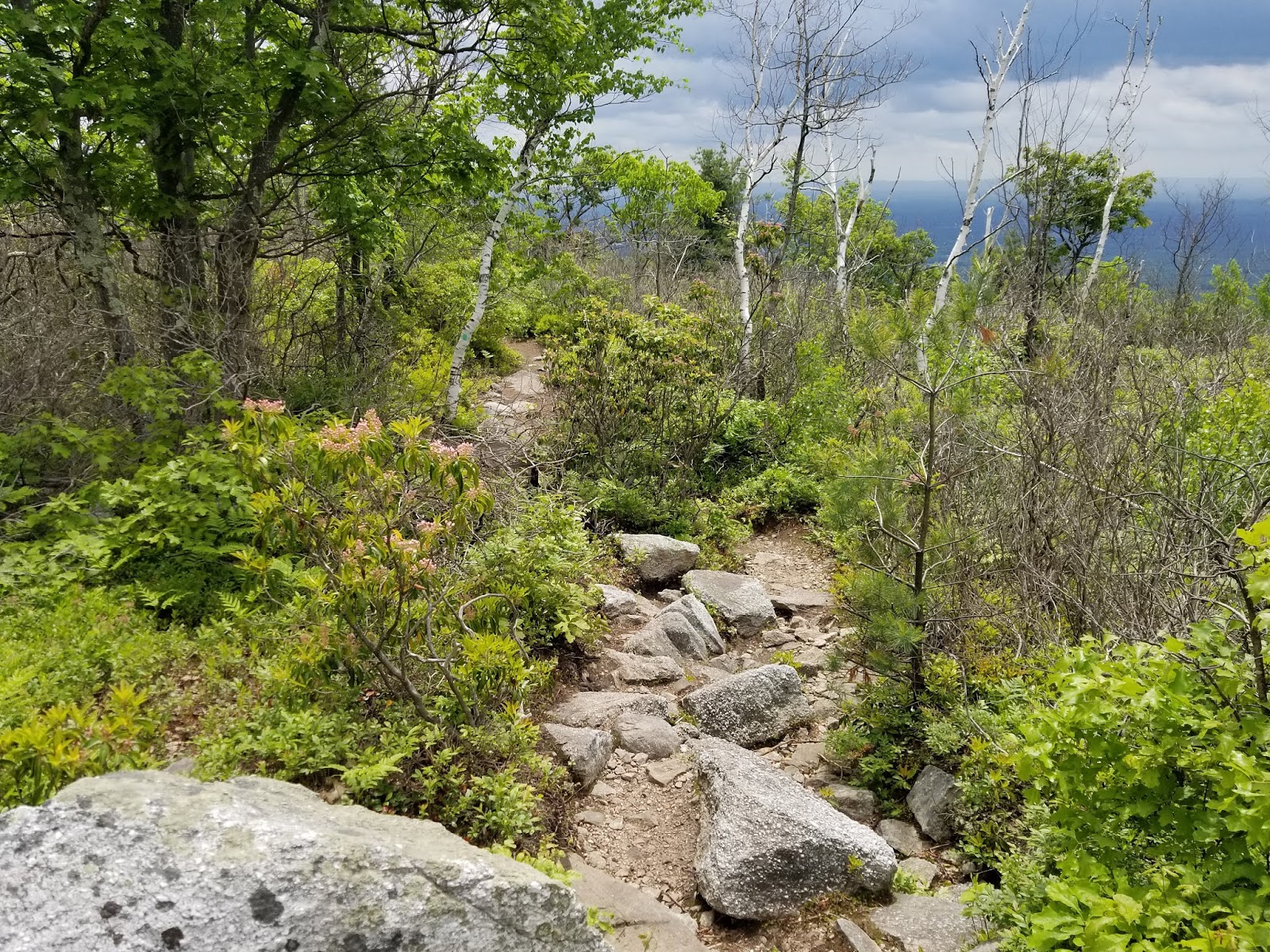
This does not last long, as the trees soon give way to exposed rock.
The next 2 miles or so is almost entirely exposed rock along the ridgeline. I would not want to be here during a thunderstorm, but the hiking is nothing short of amazing. Enough talking, let's enjoy the trail and the views it has to offer.
 |
| The trail goes along that ledge. Hope you aren't afraid of heights. |
 |
| Did I just come across that? Looking southeast. |
 |
| One of the larger scrambles on the hike |
 |
| Another ledge |
At this point, it started to rain. Thankfully, expecting rain, my trusty LL Bean rain jacket was in my backpack and I was able to stay dry.
 |
| A few cairns are located along bare stretches of rock |
 |
| The rain obstructed the view quite a bit |
With the rain, puddles were forming as I neared High Point.
 |
| The final scramble up to High Point |
High Point, elevation 2,220, is a good 70 feet lower than the highest point on the Shawangunk Ridge a little over a mile to the south. We'll be passing over that point, too, but High Point is exposed and has a view.
 |
| View southeast |
 |
| View southwest toward the true high point, at the radio towers |
 |
| View northwest toward the Rondout Reservoir |
At least one reference marker and a benchmark are present on the exposed rock at High Point.
 |
| Reference Marker #1 |
 |
| Benchmark |
With the rain and how wet everything was, I was not about to sit around and admire the view at High Point. Thankfully, shortly after I left the summit, the rain stopped and I arrived at another viewpoint as the clouds were clearing.
 |
| A clearer view of the Rondout Reservoir |
From here, the trail descends, arriving at a junction with the Berry Pickers footpath, which proceeds. The Long Trail continues onto the Berry Pickers footpath, but we do not, instead turning left to stay on the High Point footpath.
The trail descends steeply, arriving at the High Point carriage road after 0.1 mile.
 |
| Junction signs at carriage road |
Turning left at the carriage road, it's nearly 3 miles of old gravel road, much of it rolling, back to the parking lot.
The best fire evidence of the hike can be seen along the carriage road.
Crossing a large puddle, I saw several tadpoles swimming around.
Roughly 1.3 miles from the High Point footpath, we arrive at the junction with the Indian Rock footpath. At the time of writing, this trail is closed.
Continuing on, we reach the highest point on the Shawangunk Ridge, elevation 2,289 feet, where the trail passes the radio towers.
A little under 1/2 mile from the Indian Rock junction, we arrive at the loop road. Turning left leads back to the Ice Caves carriage road in 0.8 mile. Right is the shortest way to the parking lot and visitor center, roughly 1.25 miles. Right we go.
 |
| Junction signs |
 |
| Looking back down the High Point carriage road |
 |
| Looking down the loop road toward the parking lot |
 |
| More radio towers. Per my GPS, this was roughly the highest point of the trail. |
Past the last of the radio towers, we begin the descent to the parking lot and enter the forest. At a couple of places along the trail, there are abandoned buildings to the right. According to signs, these were once cabins used by berry pickers on the ridge.
Roughly 1/4 mile from the parking lot, we reach the South Gully footpath. This path takes the Long Path south to New York City.
Between the South Gully footpath and the parking lot are the remains of more cabins.
Finally, after over 10.5 miles of hiking, we're back at the parking lot.
 |
| The visitor center |
It was long, it was tiring, and it was wet for a while, but this was a hike I will never forget. I rarely do hikes multiple times, but I fully expect to return to Sam's Point to hike the Ice Caves at least once in the future.
Getting Here


