Showing posts with label Paved Trails. Show all posts

Saturday, March 3, 2018

Short Hike #1: New Croton Dam

The dam's distinctive spillway

A new category of posts I'll do concerns short hikes that take less than an hour to complete. Most of these are near major roads and can be easily completed as part of another trip. The first one here is a place I finally got to last November, the New Croton Dam in Cortlandt, NY. This dam, constructed from 1892-1906, impounds the New Croton Reservoir, part of New York City's water supply system and once the tallest dam in the world. The gorge along the lower Croton River is quite scenic and popular among locals. During the summer, there is a parking fee, but outside of the peak season, entry is free.

The parking lot for the area's trail system lies near the base of the dam, next to the Croton River. The trail, generally paved with gravel, departs from the east corner of the lot and begins climbing the side of the gorge, heading toward the Hudson River. The trail soon forks; the left trail continues climbing and left is what you want. There's a hairpin curve and we start to head back toward the dam.

The trail generally looks like this
A little over halfway to the dam, the Old Croton Aqueduct departs to the right. Now a state park, this was New York City's original water distribution system. A trail follows the abandoned aqueduct to Manhattan, crossing the Harlem River on the High Bridge. I hope to eventually hike the aqueduct and post about it here.

Typical blazes

The start of the Old Croton Aqueduct trail, now a state park

Soon enough, we reach the dam. The road across the dam was closed to vehicles after the terrorist attacks in 2001, but it remains open as a walkway.

Standard NYCDEP water supply facility sign 
A vestige of the dam's former use


Looking south along Croton Dam Road

Once you're up here, it's a flat walk across the dam.

Looking into the gorge

Partway across, looking back south


Looking east at the reservoir

Approaching the bridge (replaced 2005) over the spillway

Near the bridge, there are several plaques.


The dam and water supply system is a National Historic Civil Engineering Landmark

Continue across the bridge for some amazing views.

Crossing the bridge

The spillway

Across the bridge 
The bridge

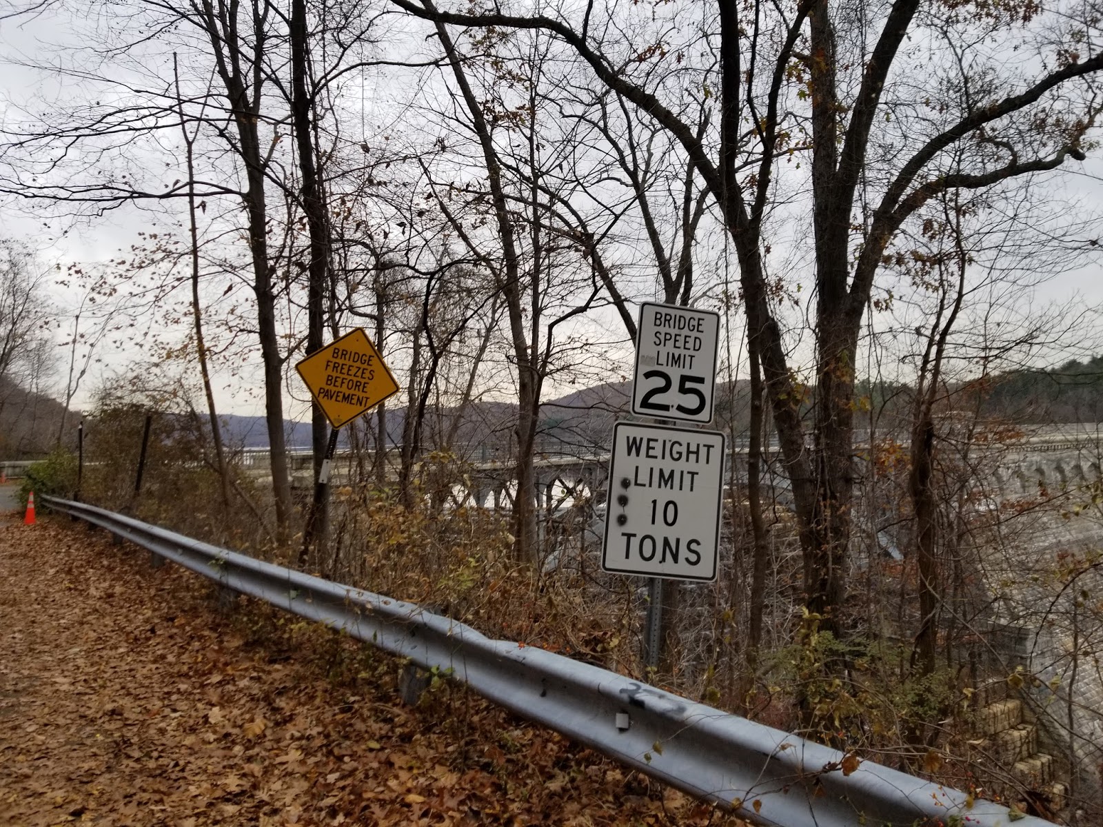
Signs that will never see another car

You don't say? 

If you continued on the road, you'd reach New York Route 129, which runs along the north side of the reservoir.

Looking north along the abandoned road 


Since I didn't want to do a road walk, I started back the way I came.


Looking west into the gorge

Once I got down into the gorge, I continued past the lot to get a good look at the dam from below.


If you walk onto the bridge carrying the entrance road (watch for cars), the park's signature view can be seen.

The bridge

Signature view of the spillway and bridge

Looking downstream toward the Hudson

From here, I returned to my car and went on my way, continuing to my next stop of the day. What was my next stop, you ask? Bailey Mountain, the highest point in Westchester County, located in Mountain Lakes Park in North Salem. That may get a "short hikes" post in the future.

Getting Here


Croton Gorge Park is located at the base of the New Croton Dam along New York Route 129, just east of Croton-on-Hudson. The park is easy to access from both US Route 9 and the Taconic State Parkway. There is a $10 parking fee Friday-Sunday from May to September.


Resources


Friday, February 2, 2018

Ghosts on the Quabbin: The Abandoned Town of Dana, Massachusetts

The now-abandoned town common in Dana
(All pictures mine unless otherwise noted)

The Quabbin Reservoir, located in a rural area of eastern Franklin and Hampshire Counties and western Worcester County, supplies much of the water used in Greater Boston. When the decision was made to flood the Swift River valley and create the reservoir, the State condemned and purchased most land in the watershed above the planned dam site in order to protect the quality of the water. Much of the watershed land, with the notable exception of the large peninsula south of New Salem, is open to the public. This makes for some unique hiking opportunities.


Four towns were dissolved on April 28, 1938 due to reservoir construction. Enfield and Greenwich were mostly low-lying and are thus mostly submerged.

The destruction of Enfield Center. Town hall in center.
The town center is now underwater.
Source: https://en.wikipedia.org/wiki/File:FarewellEnfieldTownHall.png

Prescott is mostly above water, but largely inaccessible, as most of the above-water land is on the restricted peninsula south of New Salem. And then you have Dana. Unlike the others, the former town center, Dana Common, remains accessible to the public. That is, if you're willing to park at Gate 40 and walk 1.8 miles along a long-abandoned road now used only by foot traffic, bicycles, and service vehicles.


Map of the area. Parking is at Gate 40.
Dana Common is at the intersection under the "North" arrow. (Massachusetts DCR)
Source: https://www.mass.gov/service-details/public-access-maps

January 27 was an unseasonably-warm day, so I decided to do my planned hike to Dana. Gate 40, along Massachusetts Route 32A in Petersham, has parking for 6-7 cars, but it is NOT marked. Strongly recommend using a navigation app or GPS to get here. If you insist on going in without assistance, Gate 40 is a driveway leading to the small parking lot.


The parking lot. MA Route 32A is in the background.


Don't block the gate, as it is the emergency vehicle access point for the trail and you will get towed.
The gate, kiosk in background. Sign says what is prohibited. 
Leave Fido at home. Dogs are not allowed on watershed land.


A short distance past the gate is a kiosk, providing a wealth of historical information and a map of the area.


History, map, and regulations kiosk at trailhead

The Town of Dana was settled in 1763 and incorporated in 1801. Due to water power and rail access, it became a manufacturing center, eventually becoming the first town in the Swift River Valley to have electricity and the only town in the valley to have a motorized fire truck. The town common was listed on the National Register of Historic Places in 2013.


Asphalt is in acceptable condition and the road is relatively clear

Uh, oh, looks like ice ahead

The "trail" is the old road to Dana, still with its asphalt that likely predates the 1930s. It appears to be plowed in the winter and, while I had poles, I only used them for assistance on ice.


Yup, a thick sheet of ice across the entire road for about 200 feet


It generally looks and feels like a rural road in this part of the country, minus the vehicle traffic. There's a small hut of some sort past the icy patch.


The trail was pretty lonely, and I only passed one walker and one bicyclist before I started returning to the car. About a mile in, we start seeing real signs of former residents. Cleared fields appear, along with our first house foundation on the right.


A former orchard?


Foundation of an old farmhouse?

Cleared field
Old wall

Another old wall
On the right (north) side of the road, there appears to be an old alignment of this road. It too appears to have been paved at one point, at least partially.


The old, old road

Just past the old road, evidence of habitation increases significantly, with more foundations. Around a bend is the former town center.

Another field
And just like that, we're at the town.
Text: "To all those who sacrificed their homes and way of life,
erected by Dana Reunion 1996" 


An old sidewalk on the north side of the road leads away from the common to the former town hall.
The former Dana Town Hall


Same view as above


The foundation of town hall

Another foundation is to the left of the town hall. Given the old fence nearby, I would not be shocked if this was a church.


The town common itself looks very similar to how it did when Dana was a town, minus the cannon.
Old image of Dana Common 
Cannon was in the center of those trees


Walking along the north side of the common, there are some road signs. Abandoned roads, but new signs to help people navigate.


Road to the west 
Common from the west corner
Greenwich-Dana Rd is the road you hike in on

The road continues south to Gate 43
Some ruins along the southeast side of the common

Current site of the Johnson House
There's a small road leading southeast from the common. Some more stuff is down that road. 


Such as this cool wall. Stones are much smaller than usually seen in stone walls.


Leftover junk on top of the wall


The Cooley House, before and after 
Back to the main road, there are some leftover sidewalks and more foundations.


Guess it's time to head back to the car.


But one last look at the common
And I chose the right time to return, as I passed 6 groups on the 35 minute walk back to the car.


Didn't notice the old wire fence on the SE side of the road when hiking out

Near the shack

Overall, I spent about 1:45 walking to/from and exploring the ruins, but I'm accustomed to walking on rough terrain. Even though the walk was flat, it was definitely a unique experience and a place you should visit.


Red Tape

Being as this is a public water supply, there is some red tape associated with this hike.


  • Parking is extremely limited. Not many places to park on the road nearby, either. If you show up at a busy time, good luck finding parking. You may be able to park at Gate 43 on Greenwich Rd, but it is a much longer walk and a bicycle may be useful.
  • Dogs are explicitly prohibited, as mentioned above. This is almost certainly to protect water quality. I did see one person with a dog when I was there, but I expect that the area is patrolled during nicer weather.
  • There are supposedly portable toilet facilities during the main season, but there definitely were NOT when I was here. Nearest reliable public restrooms are in Ware, Barre, and Athol.

Getting Here


While not particularly far from either Worcester or Springfield, this is a relatively remote area that gets little traffic. Cell service is limited and I did not have reception at any point during the hike. Do NOT rely on being able to find the location online if you are near the trailhead.