 |
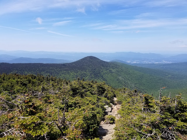
| Looking west toward Rutland, the northern Taconics, and the Adirondacks from Killington Peak (All images mine unless otherwise indicated) |
Killington, Vermont is best known as the location of America's largest ski resort east of the Mississippi River. But the town also lends its name to Killington Peak, a 4,235-foot behemoth that happens to be Vermont's second tallest peak and the highest point of Rutland County. Vermont's highest fire tower is up here as well, though it's closed to the public as it houses communications equipment.
The easiest way up Killington Peak involves taking the K1 Gondola from the resort's base area and hiking the remaining 200 or so vertical feet to the summit. But, at least in my opinion, that's cheating, plus the gondola hasn't started running for the summer season.
The typical way to climb Killington involves hiking up the Bucklin Trail from Mendon, an 8-mile round trip with roughly 2,400 feet of elevation gain. This is a beautiful, excellently-maintained trail that, while strenuous, is a very pleasant climb. While you could hike from US Route 4 at Sherburne Pass or the Appalachian/Long Trail crossing, this adds 4 miles with little to no less elevation gain. This option is really only viable if you're planning to climb Pico Peak on the same trip, which is another peak on the New England Hundred Highest list.
Ascending Killington via the Bucklin Trail involves passing through four distinct sections of trail.
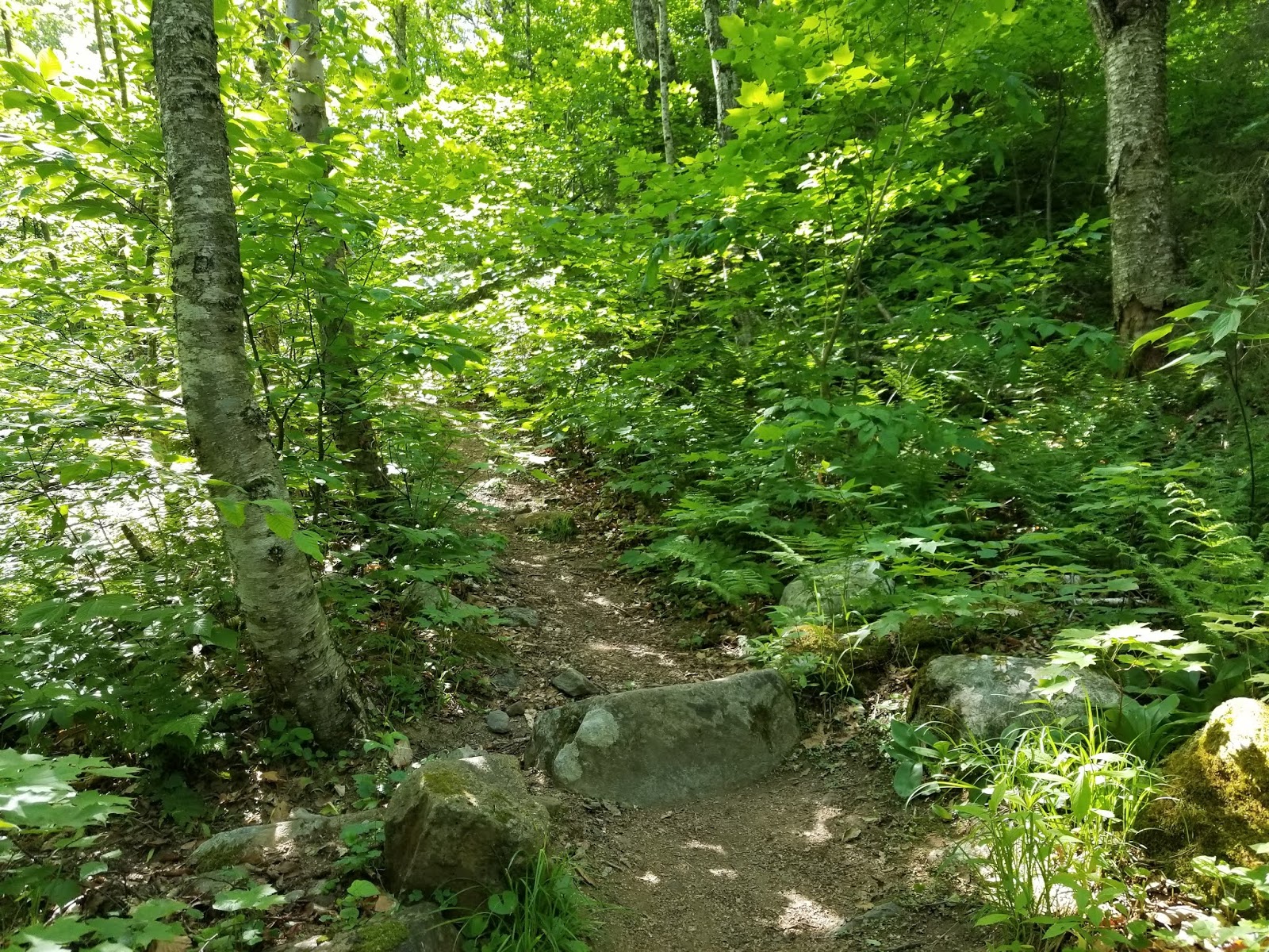
- Lower Bucklin Trail: 2.3 miles and over half of the distance is basically a "walk in the woods" rated as moderate by the Green Mountain Club. This is generally a hike along Brewers Brook on an old woods road, crossing a couple of times on bridges. There are a few ups and downs, but net elevation gain along this stretch is less than 500 feet.
- Upper Bucklin Trail: 1.3 miles of steep climbing. At least 1,500 feet of the ascent is in this portion. You know you're here because the trail makes a sharp right turn and the old woods road is brushed off. The Green Mountain Club rates this as difficult and I generally agree. Around 3,000 feet, foliage changes from deciduous trees common at lower elevations to evergreens.
- Long Trail/Appalachian Trail: At a little over 3,800 feet, the Bucklin Trail ends at the combined Long and Appalachian Trails. Go straight (south) to continue climbing Killington. You'll be on this for about 0.2 miles. There's a shelter and spring just north of the Killington Spur.
- Killington Spur: A little over 1/10 mile and almost entirely rock scrambles, as the trail climbs about 300 feet in that distance. The upper part of this trail is an exposed scramble and the wind can be quite fierce, but there are unobstructed views west toward Rutland, the Champlain Valley, and the Adirondacks. Follow the blue blazes up to the summit. This is by far the hardest part of the climb and what makes the difficulty level 5/5. The scrambles can supposedly be avoided by taking an unmarked ski trail from the shelter to the upper end of the gondola and ascending that way.
I arrived at the trailhead around 8:30 AM on a beautiful Tuesday morning. Only two other cars were in the parking lot when I arrived. A kiosk at the trailhead shows trail information and a map of this section of the Coolidge State Forest and Green Mountain National Forest.

Do note that there are several ski trails in the area. The Bucklin Trail is hard to lose, but follow the blue paint blazes.
For your reference, I attached the State Forest map below (click for larger), but since it is not topographic and not to scale, it is of relatively little use.

The Bucklin trail has blue blazes as a spur of the Appalachian Trail. The wide, flat trail enters the forest, coming to a second kiosk immediately before a bridge.

Much of the information on the second kiosk is identical to that on the first kiosk.

 |
| The Green Mountain Club's Killington Section maintains trails in this area |

Crossing the bridge, there is a sign providing distances. These distances appear to be inaccurate, as my GPS adds roughly 0.35 mile to the distances shown on the sign.


 |
| Heed the warning if you're going to Pico |

The first moderately-steep section of the trail comes about half a mile in, as the trail makes a sharp turn to the left.

This does not continue for long, and the trail proceeds to alternate ascending and descending over the next 3/4 mile.


Roughly 1.25 miles from the trailhead, the trail briefly passes through a grassy area before descending to a second bridge across the creek.


The trail turns left to continue following the creek.

A third, smaller bridge crosses a tributary of the main creek.


The trail continues, ascending gradually with a couple of stream crossings.


Roughly 2 miles from the trailhead, there's a short spur trail to the left that leads to a waterfall. I'll return here on the way down.

[-]


At 2.3 miles from the trailhead, the old woods road the trail followed is brushed off and the trail takes a hard turn to the right

 |
| This doesn't look good... |
Once we're around the corner, the easy part of the hike is over and the second part of the Bucklin Trail begins. Almost 2,000 feet to climb in the remaining 1.7 miles.


The 1.3 miles from the turn to the Long Trail is a steep climb with few flat sections. Like the Energizer Bunny, it keeps going.


 |
| Top center of the image |
Partway into the climb, roughly 2.5 miles from the trailhead, there was an inviting-looking log to the left of the trail, so I took a break.
 |
| Closest thing to a bench you'll find on this trail |
Rested, I continued on. Immediately after the log, there's a steep climb over a rocky section of trail.


 |
| Interesting hollow tree |
Much of the remaining climb to 3,000 feet is very similar, with steep climbs and the occasional stream crossing. There is a small amount of mud around the streams, but it is avoidable.


At approximately 3,000 feet, the foliage changes to evergreen trees relatively suddenly


The trail continues to climb through an evergreen forest, with soil that becomes increasingly rocky.


The environment never becomes alpine, but foliage generally tends to thin as the trail ascends.


 |
| Approaching the Appalachian Trail/Long Trail junction |
Finally, at roughly 3,800 feet and a good 3.65 miles from the trailhead, we're at the Appalachian and Long Trails.
 |
| Distance sign for Bucklin Trail |
At this junction, turning left would take you north to Pico Peak and US Route 4. Continue straight to go south on the Long Trail toward Killington Peak. As we are now on the combined Appalachian and Long Trails, blazes change to white.

In a few places, the trail climbs what is effectively a stone staircase.

Around midway along the short stretch of AT/LT we use, there's a large blowdown across the trail. A herd path has formed around the blowdown to the right.
 |
| No climbing over those trees |
Past the blowdown, there's a spur trail to the right leading to a spring. Turn LEFT here to continue on the AT/LT.


After this spur trail, we reach an orange ribbon indicating the ski resort boundary.

The Cooper Shelter is visible just past the ribbon.

 |
| Looking back, that sign is intended for skiers. |


Turn right at the shelter, climbing up the staircase to continue on the AT/LT.

At the top of the stairs is the junction with the Killington Spur. Continue straight on the blue-blazed trail to the summit.

The trail continues the climb.


Soon, it becomes a scramble. Time for the final 300 vertical feet to the summit.


This is a long, steep climb that WILL require using your hands.
 |
| Is that pile of rocks really the trail? |

Once you get high enough, you can turn around and get a great view to the west.

Turning back around...
 |
| Oh, that's right, I'm still not there |

Once you're up here, expansive views open up.


The last little bit of the climb is easy as the trail has been rerouted to the right to avoid a steep section.


 |
| The final scramble to the summit |

Once you're up top, the views are amazing. The main summit has 270-degree views.
 |
| Looking north |
|
| Looking west |
 |
| Looking northwest |
 |
| Looking south toward the towers |
The summit benchmark is not a typical USGS disc, but a bolt placed in 1874 surrounded by an etched triangle.

Surprisingly, I had the summit to myself for a good 5-10 minutes before another group appeared as I was enjoying my lunch. It was quite windy up here and I was happy I had packed a light jacket.
 |
| Another view north |
The view up here was nothing short of amazing and I spent nearly half an hour at the summit. Right before I began to head back down, I took a walk around the summit area. Along the path to the gondola (which I did not visit), there is a memorial to Big Bill Moryto.


Over here is a relatively unobstructed view to the east.
The initial part of the descent has an excellent view to the west.


At the top of the scrambles, there is a completely unobstructed view. Remember to bear LEFT here to follow the blazes.


That being said, here we go...


This section of trail, like most steep scrambles, is harder to descend than ascend. Remember to go slowly and you'll be fine. You made it up here, getting down is easy once you're past these.

Get your views while you can, because the trees soon get tall enough to obstruct the view
Once you're back in the thick foliage, the steep descent continues.

I was generally more concerned with getting down safely than taking pictures, so there aren't many of the scrambles going down. You're not missing much, as it generally looks the same.
Eventually, we're at the bottom of the scrambles and at the junction with the LT/AT

At this junction, there are three tent platforms off to the side. A path leads past the platforms to the Cooper Shelter's privy, named the Cooper Pooper.


Do note that the Cooper Pooper is only for #2. If #1 is necessary, the forest is your restroom. Off to the right of the Cooper Pooper is an enclosure containing composting human waste from the privy (this privy is emptied every once in a while as it gets a lot of use), while the unmarked trail to the Peak Lodge (containing flush toilets when open) and gondola is to the left.
Returning to the LT/AT, descend the stairs to pass the Cooper Shelter and continue north on the trail.


Turn right after the ribbon, or else you will end up at the spring.

After a short while, we're at the Bucklin Trail junction.


Continue straight here to start the steep descent down the Bucklin Trail.

In at least one spot, a hole was sawed in a log to reopen the trail.


As we descend, the foliage changes from evergreens to deciduous trees.


Back at the stream crossing, surrounded by mud


Coming up on that bench log, but I don't need a rest heading down.


Finally, we're back at the flat, easy section. Only 2.3 miles to go.
A couple more stream crossings are on this section

Coming to the waterfall spur path, I went to the side and saw the waterfall.

Returning back to the main path...

The second bridge marks the beginning of an uphill section.

The steepest uphill climb of the return trip comes shortly after the grassy area that follows the second bridge.
This goes on for a little while...
before leveling off.


Eventually, we start the final descent to the trailhead.

Cross the first bridge and it's a straight shot back to the trailhead.

Back at the trailhead, it was much warmer and buggier than at the summit. I had passed a couple of groups hiking up as I was on my way down and the parking lot had filled in slightly. With that, another great hike was in the books and I had hiked my first 4,000-foot peak of the year.
 |
| Looking east from near memorial |
I then hiked over to the base of the fire tower.

 |
| Communications equipment has occupied the tower. |
 |
| Looking east from near the fire tower. I think that mountain in the distance is Mount Ascutney, which is far taller than anything else near the Connecticut River. |
 |
| Looking south from below the towers |
Satisfied, I was now ready to head back down the mountain. Climbing back over the summit, I took one final look at the view before descending.
 |
| That really is an amazing view |

[-]


At the top of the scrambles, there is a completely unobstructed view. Remember to bear LEFT here to follow the blazes.


That being said, here we go...

 |
| The views continue for a little while |

This section of trail, like most steep scrambles, is harder to descend than ascend. Remember to go slowly and you'll be fine. You made it up here, getting down is easy once you're past these.

 |
| Yup, that's the trail. But that view! |
Get your views while you can, because the trees soon get tall enough to obstruct the view
 |
| Last shot at a view |
Once you're back in the thick foliage, the steep descent continues.

Eventually, we're at the bottom of the scrambles and at the junction with the LT/AT
 |
| Looking south on the LT/AT |
 |
| Looking north on the LT/AT |

At this junction, there are three tent platforms off to the side. A path leads past the platforms to the Cooper Shelter's privy, named the Cooper Pooper.


Do note that the Cooper Pooper is only for #2. If #1 is necessary, the forest is your restroom. Off to the right of the Cooper Pooper is an enclosure containing composting human waste from the privy (this privy is emptied every once in a while as it gets a lot of use), while the unmarked trail to the Peak Lodge (containing flush toilets when open) and gondola is to the left.
Returning to the LT/AT, descend the stairs to pass the Cooper Shelter and continue north on the trail.


 |
| If you want to get back to your car, don't return to resort |

After a short while, we're at the Bucklin Trail junction.

 |
| The next shelter is 4.5 miles to the north |

Continue straight here to start the steep descent down the Bucklin Trail.

In at least one spot, a hole was sawed in a log to reopen the trail.


As we descend, the foliage changes from evergreens to deciduous trees.


Back at the stream crossing, surrounded by mud


Coming up on that bench log, but I don't need a rest heading down.


Finally, we're back at the flat, easy section. Only 2.3 miles to go.
 |
| The turn onto the easy section |
A couple more stream crossings are on this section

Coming to the waterfall spur path, I went to the side and saw the waterfall.

Returning back to the main path...

The second bridge marks the beginning of an uphill section.

 |
| Why can't the trail just follow the old woods road here? |
 |
| Really? |
before leveling off.


 |
| Approaching the first bridge |
Cross the first bridge and it's a straight shot back to the trailhead.

 |
| Looking upstream |
 |
| Looking downstream |
 |
| View approaching the trailhead |
Back at the trailhead, it was much warmer and buggier than at the summit. I had passed a couple of groups hiking up as I was on my way down and the parking lot had filled in slightly. With that, another great hike was in the books and I had hiked my first 4,000-foot peak of the year.
Getting Here
The trailhead for the Bucklin Trail is located on Wheelerville Road in Mendon. This is a dirt road, but in decent shape. Passing other cars will be tight. It is not possible to get to this trailhead without driving for 4 miles on a dirt road. The parking lot, located at a sharp curve 4 miles south of US Route 4, is easy to find and it can hold a dozen or so cars, but I would not be surprised if it fills on weekends.
One can approach the trailhead from either US Route 4 to the north or Killington Avenue in Rutland Town to the west. If coming from US 4, the trailhead is on the LEFT at the sharp curve. If coming from Killington Avenue, the trailhead is straight ahead at the curve.
Resources
- Coolidge State Forest: Website for state forest much of the hike passes through. Contains a basic trail map of the area.
- The Green Mountain Club's Killington Area Hiking Trails Map. Topographic map of the region with trails and difficulty ratings.


